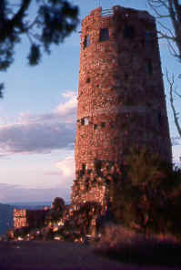
setting sun on Desert View Watchtower
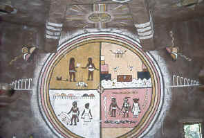
rain clouds, snakes, feathers, and other sacred
symbols appear in this Hopi Indian painting inside Desert View Watchtower
Outstanding overlooks line this 25-mile drive from Grand Canyon Village east to Desert View. Grandview Point has an especially fine panorama, plus an exciting hiking trail. Other major viewpoints on the way to Desert View include Yaki Point, Moran Point, and Lipan Point. At Lipan, by looking both up- and down-canyon, you can see the entire geologic sequence of the Canyon.
Yaki Point and South Kaibab Trailhead
The turnoff is two miles east
of Mather Point, but except in winter, visitors must take a shuttle service to these
destinations from Grand Canyon Visitor Center. Bicycling is another option. Hikers
can get an early start by taking a special year-round shuttle from Bright Angel
Lodge and the Backcountry Information Center directly to the South Kaibab Trailhead.
From Yaki Point, at road's end, you can see much of the central Grand Canyon. The
South Kaibab Trail snakes its way along Cedar Ridge below.
Grandview Point
Many people consider this aptly named point one of
the best. It's 12 miles east of Grand Canyon Village, then 0.8 mile north. Sweeping
panoramas take in much of the Grand Canyon from this commanding site above Horseshoe
Mesa. The vastness and intricacies of the Canyon show themselves especially well
here.
Historic Walk to the Grandview Hotel Site
If you'd like to seek out
a bit of history, or just get away from the crowds for awhile, it's possible to
walk out to the site of the Grandview Hotel, one of the first on the South Rim.
There's little left, just some old pipes, broken glass, and a cistern, but the view
is still grand. From the Grandview Point turnoff, drive east 0.5 mile on the highway
to an unsigned pullout on the north side just before Milepost 251 and park. Walk
east about half a mile along an old road, now open only to foot travel, then wander
over to the rim. If you continue along the rim a bit farther east you'll come to
a pair of small reservoirs.
Grandview Lookout Tower
Some of the prettiest country of the Kaibab
National Forest surrounds the lookout. You can climb the 80-foot steel tower, built
by the Civilian Conservation Corps in 1936, for a panorama of the region. Turn south
at the sign for "Arizona Trail" between Mileposts 252 and 253, two miles
east of the Grandview Point turnoff, and proceed 1.3 miles on a dirt road to the
tower. You can also drive east 15 miles on unpaved Forest Road 302 from the south
edge of Tusayan. The Kaibab Forest Map (Tusayan District) shows the way in. Mountain
bikers can follow trails from Tusayan to Grandview Lookout in 16 miles one way;
the trailhead is on the west side of AZ 64, just north of Tusayan. See the Recreation
section below for hiking, cross-country skiing, and mountain biking opportunities
near the lookout.
The historic Hull Cabin and outbuildings,
two miles from the lookout by bumpy dirt road, once belonged to a sheep ranch. You're
welcome to visit the grounds.
Tusayan Museum and Ruin
Ancestral Puebloans built this village in A.D.
1185–90, according to tree-ring dating, then stayed 25–30 years before
migrating elsewhere. Up to 30 people lived here, contending with poor soil, little
rainfall, and scarce drinking water. Archaeologists who excavated part of the site
in 1930 named it Tusayan, a Spanish term for Hopi territory. It's just south of
Desert View Drive, 22 miles east of Grand Canyon Village and 3 miles before Desert
View.
A small museum (928/638-2305, 9 a.m.–5 p.m. daily
except in winter when it may close some days) introduces the ancestral Pueblo people
and displays artifacts that they left behind. Illustrations show the village as
it may have look during its occupation. You'll also see some split-twig figures
made by archaic cultures. Other exhibits introduce modern tribes of the region.
Related books can be purchased.
Outside, a 0.1-mile paved
trail loops around the plaza and ruins of living quarters, storage rooms, and two
kivas. A short side trail leads to an area that may have been used for growing crops.
You can also take a guided tour; check The Guide for times. The trail stays
open during daylight hours, weather permitting.
Desert View
This overlook presents a stunning view at the east end
of Desert View Drive. Although the surrounding pinyon pines and junipers suggest
a lower elevation, this is one of the highest spots on the South Rim. Far to the
east lies the multi-hued Painted Desert that gave the viewpoint its name. Below,
to the north, the Colorado River comes out of Marble Canyon, then curves west through
the main part of the Grand Canyon.
The Fred Harvey Company
built the 70-foot Desert View Watchtower in 1932, using stone around a steel
frame. Architect Mary Colter incorporated design elements from both prehistoric
and modern tribes of the Four Corners region. It's not intended to be a replica
of any particular watchtower, but rather an interpretation of Southwestern cultures.
You enter the watchtower through a room shaped like a Navajo hogan with a traditional
log ceiling. Follow the stairs up to the tower's four levels. A leaflet describes
the artwork and background of the watchtower. A snake altar lies in the center of
the Hopi Room on the first floor. The large circular wall painting depicts the snake
legend. Look around for the wedding scene, gods, and other Hopi symbols. Out on
the adjacent terrace, you can view the Canyon through "reflectoscopes,"
which deepen colors of the rock layers. Continue up to the second and third levels
for a close look at replicas of Southwest petroglyphs. Finally, on the fourth level,
you can gaze out windows from the highest viewpoint on the South Rim—7,522
feet.
The hogan-like building of the Watchtower has a gift
shop. Nearby, you'll find a small information center/bookstore (9 a.m.–5 p.m.
daily), another gift shop, snack bar (opens for breakfast at 8 a.m.), picnic tables,
general store (groceries and outdoor supplies), and a service station. The large
parking area has separate sections for cars, RVs, and buses.
A short road leads to Desert View Campground ($10), which offers sites in
a pinyon pine-juniper woodland from mid-May to the end of October, weather permitting.
The campground has drinking water but lacks hookups; no reservations are taken.
|
|
|
Vicinity of Desert View
Highway AZ 64 continues east 33 miles from
Desert View to US 89 and Cameron. Sheer 800-foot cliffs drop to the riverbed from
two overlooks of the Little Colorado River Canyon on the Navajo Reservation. The
first overlook, 16.5 miles from Desert View, requires a half-mile walk out to the
best viewpoints. The second overlook, 5.2 miles farther east, has just a short walk
to the views, plus a large market of Native American jewelry, pottery, and other
crafts. Each turnoff is signed "Scenic View."
Cape
Solitude, directly above the confluence of the Little Colorado and Colorado Rivers,
lives up to its name and features amazing views of both canyons. Adventurous drivers
with 4WD can take back roads on the Navajo Reservation to the park boundary (tribal
permit needed), then walk the last 6.7 miles. Unless the Little Colorado is in flood,
you'll see turquoise-blue waters from mineral-rich springs in its canyon. Hikers
can reach Blue Springs on a very rough route, about 1.5 miles one way with an elevation
change of 2,100 feet; it's on the Navajo Reservation (tribal permit required) and
approached on 4WD roads from Desert View via Cedar Mountain or from the Kaibab National
Forest farther east. The Little Colorado offers a challenging hiking route between
Cameron and the Colorado River; conditions constantly change, and it should be avoided
when in flood. Hiking books describe some of these routes. You may find a ranger
knowledgeable in these areas; ask around at Desert View, Tusayan Ruin, and the Backcountry
Information Center. See Cameron in the Northeastern Arizona
chapter for details on obtaining Navajo tribal permits to explore this remote country
east of the Grand Canyon.