Forming of the Grand Canyon
Geologists have a difficult time
pinpointing the age of the Grand Canyon itself, though it is far younger than even
the most recent rock layers—those on the rim, which are about 250 million
years old. These lay near sea level 70 million years ago, when the earth's crust
began a slow uplift. Some time after that the ancestral Colorado River settled on
its present course and began to carve the Canyon. The big question is when! Too
much of the geologic record is missing to provide a conclusive answer yet. Studies
of river deposits have led to conflicting theories of the birth of the Grand Canyon:
any time between 5 and 70 million years ago. Even the direction of the ancestral
Colorado is in dispute—some geologists think that the Little Colorado and
upper Colorado once drained northward; a look at a map of Marble Canyon supports
this view because the tributaries suggest a tilt of the land to the north. Or perhaps
the Colorado River followed its present course but in the opposite direction, later
to be reversed by tilting of the Colorado Plateau. Other theories claim that the
Colorado and Little Colorado flowed southward either into a giant lake or into the
Rio Grande to the Gulf of Mexico. A second, younger river could have carved the
lower Grand Canyon and eventually captured the upper river near the present junction
of the Colorado and Little Colorado Rivers. Or perhaps the lake had filled to overflowing
from other sources, then broken through and carved the Little Colorado and Colorado
Rivers in a catastrophic flood about 5 million years ago. Still other geologists
stick with John Wesley Powell's theory that the Colorado has always followed
its present course after the uplift began about 70 million years ago. The problem
with this idea is that no river deposits older than 5 million years have been found
near the lower end of the Grand Canyon.
No matter how the Grand Canyon did form, gradual uplift continued, giving the waters a steeper gradient and thus greater power. Today, the South Rim reaches elevations of 7,000-7,500 feet, while the North Rim towers about 1,500 feet higher. The Colorado River drops through the Canyon at an average gradient of 7.8 feet per mile, 25 times that of the lower Mississippi.
|
|
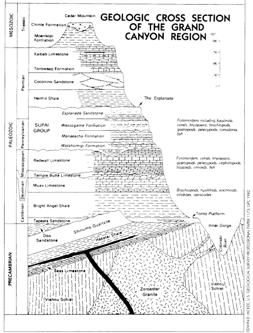
CANYON ROCKSWith 94 types of rock discovered in the Grand Canyon, how can you remember even the major formations? All you have to do is keep in mind, "Know the canyon history. See rocks made by time very slowly." From top to bottom, Know
Kaibab Limestone See
Supai Group |