|
|
|
Until 1957, only sand and desert vegetation lay atop Manson Mesa (elev. 4,300
feet) in far northern Arizona, where Page now sits. That's when construction workers
converged to build one of the largest construction projects ever undertaken—Glen
Canyon Dam. The concrete structure gradually grew to a height of 710 feet, creating
a lake covering 250 square miles with a shoreline of nearly 2,000 miles.
Prefabricated metal buildings for barracks, dining hall, and offices sprouted on
the mesa. Trailers rolled in, one serving as a bank, another as a school. Newly
planted grass and trees brought a touch of green to the desert. The remote spot
gradually turned into a modern town with schools, businesses, and churches. Page
(pop. 9,500), named by the Bureau of Reclamation for one of its commissioners, is
the largest community close to Lake Powell and offers travelers a variety of places
to stay and eat.
With the Arizona Strip to the west, Glen
Canyon National Recreation Area to the north, and the Navajo Reservation to the
east and south, Page makes a handy base for visiting all of these areas. The town
overlooks Lake Powell and Glen Canyon Dam. The extensive services of Lake Powell
Resorts & Marinas lie just six miles away at Wahweap.
Powell Museum
This varied collection (6 N. Lake Powell Blvd., 928/645-9496
or 888/597-6873, www.powellmuseum.org,
9 a.m.–5 p.m. Mon.–Fri., call for weekend hours, closed mid-Dec.–mid-Feb.,
$5 adults, $3 seniors 62 and up, $1 kids 5–12) honors scientist and explorer
John Wesley Powell. In 1869 Powell led the first expedition down the Green and Colorado
River canyons, then ran the rivers a second time in 1871–72. It was he who
named the most splendid section the Grand Canyon.
Old drawings
and photographs illustrate Powell's life and voyages. Fossil and mineral displays
interpret the thick geologic sections revealed by the canyons of the Colorado River
system. Other exhibits contain pottery, baskets, weapons, and tools of Southwestern
tribes, as well as memorabilia of early river runners, Page's early days, and Glen
Canyon Dam. You can watch related videos on request. Regional books, videos, and
posters are for sale. Staff offer travel info and can book Lake Powell boat tours,
float trips, Antelope Canyon tours, and scenic flights.
Navajo Village
Navajo offer cultural programs about their beliefs and
traditional skills from April to October at this living museum (928/660-0304,
http://navajovillage.com). The four-hour
An Evening with the Navajo begins with demonstrations of cooking, weaving, and silversmithing,
along with explanations of the sweat lodge and the two types of hogans here. You'll
enjoy a dinner of traditional foods, watch song and dance performances, and listen
to campfire stories.
The Best Dam View
An excellent panorama of Glen Canyon Dam and the
Colorado River can be enjoyed just west of town. It's reached via Scenic View Road
behind Denny's Restaurant off US 89; turn west at the junction of US 89 and N. Lake
Powell Boulevard or west beside the Glen Canyon N.R.A. headquarters building and
turn at the sign for "scenic overlook." A short trail leads down to the
best viewpoint.
Rimview Trail
An eight-mile trail for walkers, joggers, and cyclists
encircles Page with many views of the surrounding desert and Lake Powell. The unpaved
route generally follows the edge of the mesa and has some sandy and rocky sections
that will challenge novice bike riders. If you find yourself more than 30 vertical
feet below the mesa rim, you're off the trail. You can pick up a map from the chamber
office. A popular starting point is at the short nature trail loop near Lake View
School at N. Navajo Drive and 20th Avenue in the northern part of town.
|
|
|
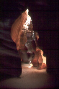
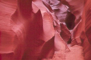
Antelope Canyon
You'll see photos around town of the beautifully convoluted
rock in this canyon, so narrow in places that you have to squeeze through. Sunshine
reflects off the smooth Navajo Sandstone to create extraordinary light and colors
that entrance visitors. Light beams reach the floor of upper Antelope only at midday
from May to August. Photographers need to bring a tripod to help capture the infinite
colors, shapes, and patterns. Check the weather forecast before heading out, as
slot canyons are deadly during a flash flood.
Antelope Canyon
has a wider upper section known as "Corkscrew" that's exceptionally user-friendly—it's
an easy walk on the sandy floor all the way through. The narrower lower section
has ladders and requires a bit of scrambling. The shallow wash in between that you
see from the highway gives no hint of the marvels up or downstream. Both sections
can easily be reached from Page by driving south on Coppermine Road or east on AZ
98 to the junction at Big Lake Trading Post, then continuing east one mile on AZ
98 toward the power plant. Turn right into the parking area for the upper canyon,
or turn left half a mile on paved Antelope Point Road for the lower canyon. You'll
pay $6 for a tribal entry permit—good for all sections—plus shuttle
or entry fees. Sightseers can tour either section easily in an hour; photographers
will probably wish to spend more time. The upper section has a $15 shuttle charge
for the 3.5-mile drive to the trailhead and a one-hour guided visit; no walk-ins
or private drive-ins are permitted. The cost increases to $25 for a two-hour photographer
tour; a two-hour stay limit may apply. The lower canyon can be visited on guided
or self-guided walks for $12.50 plus the $6 park fee. Children pay less. Guided
excursions from Page to upper Antelope tend to be more convenient and cost only
slightly more; see Tours, below.
Rattlesnake Canyon,
located near upper Antelope, also has beautiful narrow passages. It's reserved for
photographers, who pay $25 first hour and $5 each additional hour. The upper Antelope
ticket office provides a shuttle service.
The upper canyon
ticket booth is usually open 8 a.m.–5 p.m. daily April–Oct., then about
9 a.m.–3 p.m. daily in winter. The lower canyon closes by 4 p.m. Note that
these hours are the same as Page, which does not go on Daylight Savings Time. Try
to avoid coming late in the day as the canyons may close early if business is slow.
For information and off-season access, call the Antelope Canyon Navajo Tribal Park
(928/698-2808) in LeChee, four miles south of Page. Both the upper canyon ticket
booth and the LeChee office issue Rainbow Bridge hiking permits.
Horseshoe Bend Overlook
The Colorado River makes a sharp bend below
this spectacular viewpoint. Look for the parking area just west of US 89, 0.2 mile
south of Milepost 545; it's 2.5 miles south of Page's Gateway Plaza. A three-quarter-mile
trail (one way) leads from the parking over a sandy ridge to the overlook. Photographers
will find a wide-angle lens handy to take in the whole scene. Late mornings have
good light for pictures; afternoons can be dramatic if the sky is filled with clouds.