 Speed
Week at Bonneville Salt Flats International Speedway
Speed
Week at Bonneville Salt Flats International Speedway
Speed
Week at Bonneville Salt Flats International Speedway
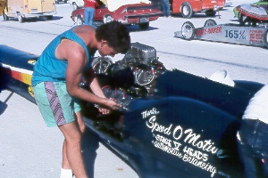
A brilliant white layer of salt left behind by prehistoric Lake Bonneville covers more than 44,000 acres of the Great Salt Lake Desert. For much of the year, a shallow layer of water sits atop the salt flats. Wave action planes the surface almost perfectly level—it's said that the curvature of the earth can be seen here. The hot sun usually dries out the salt flats enough for speed runs in summer and autumn. Cars began running across the salt in 1914 and continue to set faster and faster times. Rocket-powered vehicles have exceeded 600 mph. Exceptionally long and wide courses can be laid out; the main speedway is 10 miles long and 80 feet wide. A small tent city goes up near the course during the annual Speed Week in the third week of August, when vehicles of an amazing variety of styles and ages take off individually to set new records for their class. The salt flats, just east of Wendover, can easily be visited. Take I-80 Exit 4 and follow the paved road five miles north, then east. Signs and markers indicate if and where you can drive on the salt. Soft spots underlain by mud can trap vehicles venturing off the safe areas. Take care not to be on the track when racing events are being held!
 hiking
on Deseret Peak; the Great Salt Lake lies in the distance on the left
hiking
on Deseret Peak; the Great Salt Lake lies in the distance on the left
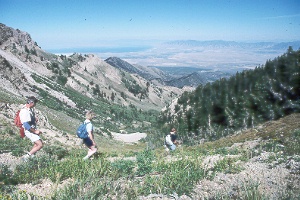
Hikers enjoy expansive views amidst alpine forests and glacial cirques in the Deseret Peak Wilderness Area, in the central portion of the Stansbury Mountains west of Tooele. The moderately difficult 3,600-foot climb to the summit is 7.5 miles roundtrip. Most of the way is easy to follow, though it's recommended that you carry the USGS topo maps Deseret Peak West and Deseret Peak East (7.5-minute) or Deseret Peak (15-minute). Trail begins from Loop Campground at the end of the road up South Willow Canyon and connects to make a loop to the summit. After three-quarters of a mile the main summit trail turns left and follows Mill Fork (the trail forking right leads to an alternate summit trail and to North Willow Canyon). The main trail ascends two more miles through meadows, aspen, Douglas fir, limber pine, and a glacial cirque to a high ridge at 10,000 feet. Follow the ridge west three-quarters of a mile to Deseret Peak (elev. 11,031 ft.). On a clear day atop the summit you can see much of the Wasatch Range on the eastern horizon, the Great Salt Lake to the north, Pilot Peak in Nevada to the northwest, Great Salt Lake Desert to the west, and countless desert ranges to the southwest. To make a loop, follow the trail along the north ridge about 1.5 miles, contouring on the west side of three smaller peaks, then drop east half a mile into Pockets Fork. At the junction with the trail connecting North and South Willow canyons, turn right 1.25 miles back to the trail junction in Mill Fork, three-quarters of a mile from the start. For other trails and access roads in the Stansburys, see the topo and Wasatch-Cache National Forest maps. Only foot and horse travel are permitted in the wilderness area (west of Mack Canyon-Big Hollow Trail, north of Dry Canyon, and south of Pass Canyon).
 charcoal
kilns at Frisco ghost town
charcoal
kilns at Frisco ghost town
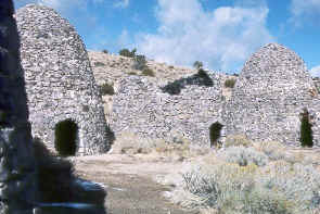
The Horn Silver Mine, developed in 1876 at the south end of the San Francisco Mountains, was the first of several prolific silver producers. Smelters, and charcoal ovens to fuel them, sprouted up to process the ore. A wild boom town developed as miners flocked to the new diggings. The railroad reached Frisco in 1880 and later extended to nearby Newhouse. Frisco's population of 6,000 included quite a few gamblers and other shady characters. Twenty-three saloons labored to serve the thirsty customers. Gunfights became an almost daily ritual for a while, keeping the cemetery growing. Yet all came to an end early in 1885 when rumblings echoed from deep within the Horn Silver Mine between shifts. The foreman luckily delayed sending the next crew down, and a few minutes later the whole mine collapsed with a deafening roar that broke windows in Milford 15 miles away. Out of work, most of the miners and business people moved on. More than $60 million of silver and other valuable ores had come out of the ground in the 10 frenzied years. Some mining has been done on and off since, but Frisco has died.
Today Frisco is one of Utah's best-preserved mining ghosts, with about a dozen stone or wood buildings surviving. A headframe and mine buildings, still intact, overlook the town from the hillside. Five beehive-shaped charcoal kilns stand on the east edge of Frisco. You can see the kilns and the townsite if you look north from UT 21, 15 miles west of Milford, between Mileposts 62 and 63. Dirt roads wind their way in. An historical marker for Frisco is at the turnoff for the town; the turnoff for the beehive kilns is 0.3 mile east. Hiking off the roads can be very dangerous near the old mines and time-worn buildings.
 Notch
Peak at sunset
Notch
Peak at sunset
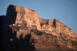
The House Range about 45 miles west of Delta offers great vistas, scenic drives, wilderness hiking, and world-famous trilobite fossil beds. Swasey Peak (elev. 9,669 ft.) is the highest point. From a distance, however, Notch Peak's spectacular 2,700-foot face stands out as the most prominent landmark in the region. What the 50-mile-long range lacks in great heights, it makes up for in massive sheer limestone cliffs and rugged canyons. Precipitous drops on the west side contrast with a gentler slope on the east. Hardy vegetation such as juniper, pinyon pine, mountain mahogany, and sagebrush dominates the dry slopes. Bristlecone pines grow on high ridges of Swasey and Notch peaks; the long-lived trees are identified by inward-curving bristles on the cones and by needles less than one and a half inches long in clusters of five. Some of the high country also harbors limber pine, ponderosa pine, white fir, Douglas fir, and aspen. Wildlife includes mule deer, pronghorn, chukar partridge, bald and golden eagles, and peregrine falcon. Wild horses roam Sawmill Basin northeast of Swasey Peak. Permanent water occurs only at a few scattered springs in the range. Limestone caves attract spelunkers, especially Antelope Spring Cave near Dome Canyon Pass (ask directions at the BLM office in Fillmore or from the Speleological Society of Utah). Council Cave on Antelope Peak (between Notch and Swasey Peaks) has an enormous opening, visible for more than 50 miles.
Mining in the range has a long history. Stories tell of finding old Spanish gold mines with iron tools in them that crumbled to the touch. More recently, the east side of Notch Peak has been mined for tungsten and gold. Outlaws found the range a convenient area to hide out; Tatow Knob (north of Swasey Peak), for example, was a favorite spot for horse thieves. Death Canyon got its name after a group of pioneers became trapped and froze to death; most maps now show it as Dome Canyon.
On to Photos of Central Utah
Return to beginning of Photo Gallery
Home