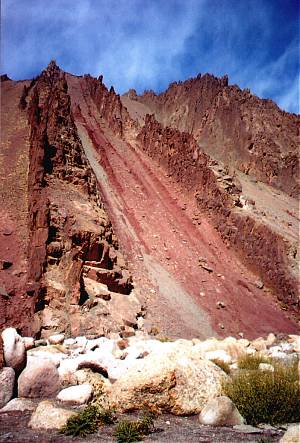
These colorful rock layers appeared in a tributary canyon
of the Indus near the beginning of the climb to Taglang La (5328 m)—claimed
to be the world's second highest road pass.
Bill and Bessie Too prepare to head south
Leh, Ladakh, India
16 September
2002
I've been resting up, eating a lot, and getting ready for the next big adventure—a ride south over four major passes to Spiti Valley in Himachal Pradesh. Spiti, like Ladakh, is also dominantly a Tibetan Buddhist area in the rain shadow of the Himalaya.
Tomorrow I plan to ride to Hemis Gompa, one of the largest and richest of Ladakh. It'll be an easy ride of about 45 km. Then comes pass #1, Taglang La at 5328 meters, said to be the world's 2nd highest road pass, though I crossed one in Tibet that was about the same height. I'll take two days to get up and over. Everything depends on the weather, which has been getting cooler. The snow level has been dropping the last few days, too. The other obstacle will be Indian bureaucracy—because the road goes very near the Tibetan border, I'll need an "Inner Line Permit" to continue downriver from the Spiti area to Lahaul and the lower Himalaya.
I recommend a visit to Ladakh for the very friendly people (except Kargil-area kids) and stunning scenery. Trekking is popular here too, and I may return another year to do some walks. Most of the population in Leh is Buddhist, and there are many gompas and chortens (stupas) scattered around. Muslims have been here a long time, and their Jama Masjid (mosque) in the center of Leh dates from about 1666. Some friction has occurred between the two groups in the past, but things seem peaceful now. There's also a tiny Christian community as a result of 19th C. German Moravian missionaries.
You've probably been reading about the Jammu & Kashmir state assembly elections in the Srinagar area. The election here in Leh was a non-event. The reason? All but one candidate dropped out! The Buddhist people in Ladakh have been pushing for greater autonomy from the rest of Jammu & Kashmir state, because the Ladakhis and Kashmiris have little in common. Indian politics, as reported in the local press, seem to be a major source of entertainment for the Indian people!
Bill and Bessie Too tell their tales of the Himalaya: Part One—Leh to Udaipur
Manali, Himachal Pradesh, India
26 October 2002
Yes, I am alive and well after the long ride across the Himalaya! Bessie Too and I have had a wild and spectacular ride—and we're not quite done yet! Since leaving Leh back on September 19th, I've been far from Internetland. Telephones usually don't work and even newspapers are a rarity. We hope you weren't worried about us!
Yesterday I pulled into the resort town of Manali near the upper end of the Kullu Valley. Beautiful mountains and picturesque villages surround Manali—a popular destination for Indian honeymooners—but the town itself is full of ugly concrete buildings. For cyclists, this is a good place to catch up on e-mail and eating!
I'll divide the long journey from Leh into four parts. Here's #1:
The weather hadn't been so good in Leh the past couple of days, and I'd heard that the Taglang La—the first of three very high passes—was closed due to snow. I set out anyway, heading south up the Indus River past the hilltop Shey and Tikse monasteries. Rain showers ahead threatened for a while, and then faded away. A stiff 7-km climb wound up to Hemis Monastery (early 17th C.), one of the most famous of Ladakh, and set in a pretty wooded side valley out of sight from the Indus. A monk showed me and some other tourists into two halls of the massive main building and a smaller room around back, where a few monks were chanting. Statues and frescoes portrayed Buddhas and many Tibetan gods.
Taglang La (5328 m) is said to be the world's second highest road pass, so I decided to spread it out over two days. I spent the night near the Indus at Upshi, where people reported that the pass was now open. The next morning I followed a sparkling stream up a narrow canyon with colorful geology. Red and green layers of shale had tilted 90 degrees—few rock layers in this part of the Himalaya seem to remain in their original horizontal position! I arrived at Rumtse, the last village, early in the afternoon and had dinner at the Sugar & Spice Restaurant, which claimed to serve the world's highest dosas and idlis; unfortunately these were out of stock, but I had some tasty samosas along with a simple Indian dinner, then camped nearby on a meadow beside an icy stream; I was grateful for my warm sleeping bag during the frosty night.
All next morning and part of the afternoon I wound up a valley, then climbed countless switchbacks, gradually inching toward the pass. A Hindu temple and Buddhist prayer flags marked the summit, which had just a bit of snow. Everyone knows that one must take shoes off before entering temples, but here and atop Khardung La, visitors were mercifully allowed to keep their shoes on when treading across the ice-cold temple floors!
The road made a great sweeping curve down the other side of the pass to the Morey Plain. This series of wide valleys has no streams or springs—I would have to keep going to the river at Pang, about 60 km away, for the next water source. Helpful tailwinds gave added speed across the flat terrain to the brink of the canyon above Pang. A steep descent led to a tent village near the river, which I reached as darkness fell. The day's ride had been a breathtaking 101 km! A Ladakhi woman led me into her parachute-tent hotel and fixed up a good dinner. I collapsed in the adjacent dormitory tent afterward.
Another day, and another big pass—actually a double one. I got cold feet at the start of the day, though—the bridge had washed out and I had to wade through frigid waters of a small river. The road turned away from the river and entered a narrow spectacular canyon. Many turns of the pedals later, I topped out at 5060-m Lachlung La, dropped to a steam, then up again onto the other side of a gorge. I spotted a couple of groups of goat-like antelopes, called ibex. Then some fun—a wild descent down the 21 Gata Loops (hairpin bends) to the beautiful blue waters of the Tsarap River. Farther upstream I stopped for the night at a tent camp in Sarchu.
Much of the road between Leh and Manali passes through wilderness, visited only in the summer by nomads, motorists, cyclists, and trekkers. Roadside tent camps all pack up and go home from October to early June. The road has been paved due to its importance for the military, but landslides and washouts have taken out the asphalt in thousands of places.
Another pass, of course, the next day and I followed the river ever higher to Baralacha La, a three-way pass at 4883 meters. It's the source for the Tsarap River I had just come up, the Bhaga (Sun) River I would be going down, and the Chandra (Moon) River I would meet later. At the pass, icy peaks towered over a vast snowy plain. I turned west down the rough road, bouncing past road workers and army camps to the first village I'd seen in several days, Darcha. I could have stayed here in a basic guesthouse, but I knew that just 7 km farther in Jispa lay a luxury hotel with real beds and hot showers. It was a splurge, but the $12 was worth it! I celebrated with a Chinese dinner.
Keylong lies only 25 km downriver from Jispa, but what a wild ride! The road climbed higher and higher on the hillside with spectacular panoramas of the river and high peaks. Juniper trees and sage on the hillsides had scents that reminded me of Arizona. At Keylong, the district center for the area, I got a room in a comfortable hotel and enjoyed meals at good restaurants. I took some walks and gave Bessie Too a much-needed wash.
Back on the road, it was just a short ride to the confluence of the Bhaga and Chandra Rivers, which becomes the Chandrabhaga or Chenab. I turned downriver past prosperous-looking villages. Local people were busy harvesting potatoes and bagging them for transport out before snows cut off all roads to the area. Large pine and fir trees covering the mountainsides in the warm valley. A side trip led up a ridge to the unusual Triloknath Temple, presided over by a Buddhist monk. The central deity is Buddhist—a white marble Avalokitesvara (god of compassion), flanked by a bronze Maitreya (future Buddha) and the Hindu gods Ganesh and Shiva. The shikara-style temple looks Hindu from the outside, and the monk gave out prasad (blessed sweets) as in a Hindu temple. Pilgrims from both religions come here. I spent the night in Udaipur, just 2650 meters (9,000 feet) in elevation.
These
colorful rock layers appeared in a tributary canyon
of the Indus near the beginning
of the climb to Taglang La (5328 m)—claimed
to be the world's second highest
road pass.
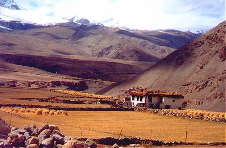
Rumtse Village
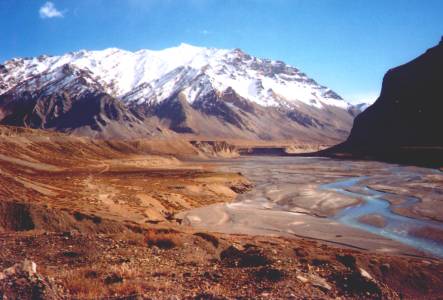
I've descended the Gata Loops to this wide valley after crossing the double pass
of Lachalung La (5060 m) and Nakli La (4900 m). The tent camp of Sarchu,
where
I would spend the night, lies at the base of the mountain in the distance .
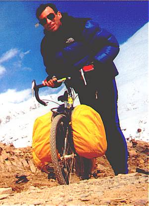
Bill Weir and "Bessie Too the Bicycle" catch their
breaths atop Baralacha
La (4883 m).
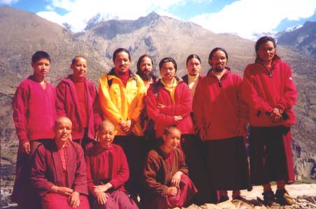
I hiked to Khardong Gompa, reached by a steep trail from Keylong.
Lamas
and nuns live here.
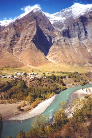 The
Chenab River begins here, just below the confluence of the Bhaga
The
Chenab River begins here, just below the confluence of the Bhaga
and Chandra Rivers.
Much of the water will be diverted to farmlands on the thirsty plains
of Rajasthan
and Punjab before the Chenab meets the Indus River in central Pakistan.
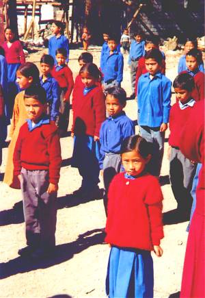
School kids start their morning with drills, exercises, and songs in Udaipur.
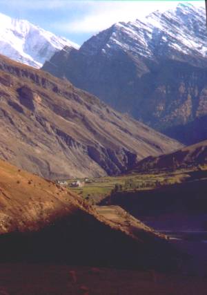 Heading
up along the Chenab
Heading
up along the Chenab
Next: Cycling from Udaipur over the Kunzum La to Tabo Gompa in Spiti