Eastern Arizona
|
Petrified Forest National Park
Like the Grand Canyon, this park presents an open book to the
earth's past. It lies in the Painted Desert, whose colorful hills
provide a world-famous resource of petrified wood and related fossils.
Layers of the Chinle—a widespread geologic formation delicately
tinted with reds, grays, oranges, and whites—have eroded to reveal
remains of life frozen in stone from 225 million years ago. Rivers in
that period carried fallen trees, some of which had towered almost 200
feet high, onto the flood plains. Waterborne minerals transformed the
logs to stone, replacing wood cells and filling the spaces between with
brightly colored quartz and jasper crystals. This now-arid land would
be unrecognizable today to its ancient inhabitants: primitive fish,
massive amphibians, and fearsome reptiles.
|
|
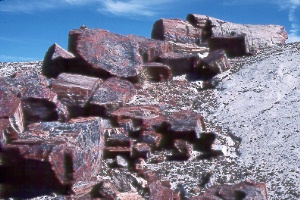
Crystal Forest
Some of the prettiest and most
concentrated petrified wood in the park lies along the paved half-mile
Crystal Forest Loop Trail.
|
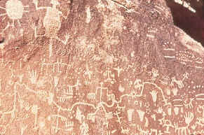 Newspaper
Rock Newspaper
RockAn impressive collection of
ancient petroglyphs covers a huge sandstone boulder. The drawings have
not been interpreted, but they seem to represent animals and spiritual
figures. Bring binoculars to better examine the artwork or use the free
telescopes.
|
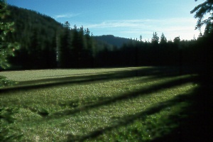 Mt.
Baldy Wilderness,
Mt.
Baldy Wilderness,
southwest of Greer
The pristine forests and alpine meadows of 11,590-foot Mt. Baldy present a fine
opportunity to visit a subalpine vegetation zone. You'll see magnificent forests
untouched by commercial logging. Engelmann and blue spruce dominate, but quaking
aspen, white fir, corkbark fir, Douglas fir, southwestern white pine, and ponderosa
pine also cover the slopes. You might catch a glimpse of elk, mule or white-tailed
deer, black bear, beaver, wild turkey, blue grouse, or other wildlife. Mount Baldy
is an extinct volcano eight or nine million years old, worn down by three periods
of glaciation.
West Fork #94 and East Fork #95 trails follow
the respective branches of the Little Colorado River on the northeast slopes of
Mt. Baldy. Each trail is 6.5 miles long; they meet on the grassy summit ridge. The
summit is another mile away, but the last half mile of trail crosses White Mountain
Apache land, which is closed to outsiders. The Apache vigorously enforce this closure—errant
hikers have been arrested and their gear confiscated—so don't try to sneak
in! Apache still make pilgrimages to this sacred peak.
Hiking season stretches from June to October, but plan to be off the ridges by
early afternoon in July and August to avoid thunderstorms. The trailheads, about
four miles apart by road, are easily reached from Sunrise, Big Lake, or Greer. In
fact, both trails also go north to Greer, about five miles away. The West Fork Trailhead
(elev. 9,240 feet) lies just outside the wilderness boundary at the end of Forest
Road 113J, a half mile in from AZ 273. The East Fork Trailhead (elev. 9,400 feet)
begins near the Phelps Cabin site, 0.2 mile in from AZ 273. An all-day or overnight
loop hike uses a 3.3-mile connecting trail that joins the lower ends of West Fork
and East Fork trails. This trail, which may not appear on maps, goes from the West
Fork Trail (0.3 mile up from the trailhead) to the Phelps Cabin site area.
On to Photos of Utah
Return to beginning of Photo Gallery
Home