Grand Canyon and the Arizona Strip
|
 sunset
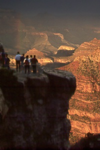
drama from Mather Point on the Grand Canyon's South Rim sunset
drama from Mather Point on the Grand Canyon's South Rim
A thunderstorm had soaked many visitors on this July afternoon before the sun
broke through to create rainbows and illuminate canyon cliffs against the dark clouds.
Inclement weather can produce wonderful spectacles of shadow and light, most often
experienced during winter or late summer.
|
 Desert
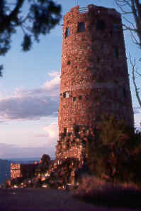
View Watchtower on the East Rim/Desert View Drive Desert
View Watchtower on the East Rim/Desert View Drive
The Watchtower, designed by Mary Colter, incorporates design elements from both
prehistoric and modern Indian tribes of the region. The Fred Harvey Company built
the 70-foot structure in 1932, using stone around a steel frame. The interior contains
reproductions of Hopi paintings and petroglyphs; stairs lead to several levels inside
and to an outdoor terrace. You enter the watchtower through a room shaped like a
Navajo hogan with a traditional log ceiling.
|
 Rain
clouds, snakes, feathers, and other sacred symbols appear in this Hopi Indian painting
inside Desert View Watchtower. Rain
clouds, snakes, feathers, and other sacred symbols appear in this Hopi Indian painting
inside Desert View Watchtower. |
 The
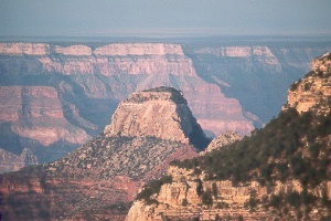
Grand Canyon from Bright Angel Point on the North Rim The
Grand Canyon from Bright Angel Point on the North Rim
The North Rim offers an experience very different from that of the South Rim.
Elevations 1,000 to 1,500 feet higher result in lower temperatures and nearly 60%
more precipitation. Rain and snowmelt have cut deeply into the North Rim so that
it is now about twice as far back from the Colorado River as the South Rim.
|
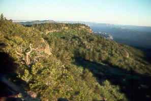 atop
Mt. Logan on the Arizona Strip
atop
Mt. Logan on the Arizona Strip
(north of the Grand Canyon)
Mount Logan Wilderness
Scenic features of this 14,600-acre
volcanic region include Mt. Logan (7,866 feet), other parts of the Uinkaret Mountains,
and a large natural amphitheater known as Hell's Hole. A jeep road climbs the east
side of Mt. Logan to within a half mile of the summit; the rest of the way is an
easy walk—just continue north along the edge of the ridge. On top you can peer
into the vast depths of Hell's Hole, a steep canyon of red and white rock. The sweeping
panorama takes in much of the Arizona Strip and beyond to mountains in Nevada and
Utah. Trees, however, block views to the south.
On the trail in the Grand Canyon
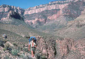 Tina
Dodd and Tony Rose hiking the Tonto Trail near Grapevine Canyon
Tina
Dodd and Tony Rose hiking the Tonto Trail near Grapevine Canyon
Tonto Trail
Canyon views change continually along this 92-mile
trail as it contours along the Tonto Platform, winding in and out of countless canyons
and sometimes revealing spectacular panoramas from the edge of the Inner Gorge.
The Tonto connects most of the trails below the South Rim between the mouth of Red
Canyon at Hance Rapids and Garnet Canyon far downstream. Average elevation on the
gently rolling trail is 3,000 feet. You might lose the trail occasionally, but with
attention to rock cairns and the map, you'll soon find it again. The sun bears down
relentlessly in summer, when it's best to hike elsewhere.
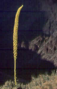 Utah
agave or century plant (Agave utahensis) overlooking the Grand Canyon's
Inner Gorge
Utah
agave or century plant (Agave utahensis) overlooking the Grand Canyon's
Inner Gorge
This species grows eight to 10 years, blooms only once, then dies. Its yellow
blossoms appear in May or June, but the tall stalk can remain standing long afterwards.
Hooked spines on the edges of the leaves distinguish the agave from the similar
looking yucca.
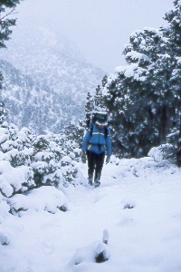 Saddle
Mountain Trail after a surprise November snowstorm on the North Rim
Saddle
Mountain Trail after a surprise November snowstorm on the North Rim
Colleen Huston and the author had been hiking on the Nankoweap Trail when we
stopped for the night. Next morning we found six inches of snow on the narrow ledges
that lay between us and home!
Nankoweap Trail
Thrilling ledges on the Nankoweap Trail discourage
hikers afraid of heights. But if you don't mind tiptoeing on the brink of sheer
cliffs, this trail will open up a large section of the park for your exploration.
The trailhead lies at Saddle Mountain Saddle, 2.4 crow-flying miles northeast of
Point Imperial. You must approach on foot, either three miles one way from House
Rock Buffalo Ranch Road (south from US 89A), or three miles one way from near the
end of Forest Road 610 (east off AZ 67). Both access roads are dirt, passable by
cars, but House Rock Buffalo Ranch Road lies at a lower elevation and is less likely
to be snowed in.
The Nankoweap Trail drops several hundred feet, then contours along a ledge all
the way to Tilted Mesa before descending to Nankoweap Creek. Some care in route-finding
is needed between Tilted Mesa and the creek. Nankoweap Creek, 10 miles from the
trailhead, is the first source of water; you may want to cache water partway down
to use on your return. The remaining four miles to the river is easy. Allow three
to four days for a roundtrip journey, with an elevation change of 4,800 feet.
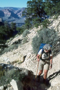 a
tired Peggy Taylor on the upper Hermit Trail; She’s almost to the top after
several days of hiking a loop from Hermit’s Rest to the Colorado River and
back via the Boucher, Tonto, and Hermit trails.
a
tired Peggy Taylor on the upper Hermit Trail; She’s almost to the top after
several days of hiking a loop from Hermit’s Rest to the Colorado River and
back via the Boucher, Tonto, and Hermit trails.
Hermit Trail
Although named for Louis Boucher, the trail
was actually built for tourists by the Santa Fe Railroad in 1912. Visitors took
this route to Hermit Camp, which operated until 1930. Most of Hermit Trail is in
good condition; the few places covered by rock slides can be easily crossed. The
trail begins just beyond Hermit's Rest, at the end of eight-mile West Rim Drive.
Water is available at Santa Maria Spring (two miles one way) and Hermit Creek (seven
miles one way). Hermit Rapids on the Colorado River is an easy 1.5-mile walk down
the bed of Hermit Creek; a sign on the Tonto Trail points the way. Elevation change
from rim to river is 4,300 feet; allow five to six hours going down and eight to
10 hours climbing out.
Hermit Trail also connects with Waldron, Dripping Springs, and Tonto trails.
Day-hikers can head to Dripping Springs, a six-mile roundtrip hike requiring four
to six hours with an elevation change of 800 feet. Descend the Hermit Trail 1.5
miles, then turn left 1.5 miles on Dripping Springs Trail. Carry water for the entire
trip, as the springs offer only a tiny flow. The 22.5-mile Hermit Loop hike, which
follows the Hermit, Tonto, and Bright Angel trails, is quite popular. You can find
water on this loop year-round at Monument Creek and Indian Garden. Hikers can easily
descend the bed of Monument Creek to Granite Rapids, 1.5 miles one way.
 Ribbon
Falls pours into a miniature paradise of lush greenery, nestled in a side canyon
a short hike off the North Kaibab Trail.
Ribbon
Falls pours into a miniature paradise of lush greenery, nestled in a side canyon
a short hike off the North Kaibab Trail.
North Kaibab Trail
Few other Canyon trails compare in the
number of interesting side trips and variety of scenery. Hikers on this trail start
in the cool forests of the North Rim, descend through the woods into Roaring Springs
Canyon, then follow rushing Bright Angel Creek all the way to the Colorado River.
Look for the trailhead at the lower end of the parking lot, two miles north of Grand
Canyon Lodge. Snows close the road from some time in October or November until mid-May,
but you can reach the lower end of the North Kaibab at Bright Angel Campground year-round
on trails from the South Rim. A long section of trail between the rim and Roaring
Springs has been cut into sheer cliffs; waterfalls cascade over the rock face in
spring and after rains. A picnic area near Roaring Springs makes a good destination
for day-hikers; it's 9.4 miles roundtrip from the North Rim and has an elevation
change of 3,160 feet; there's water from May to September.
Cottonwood Campground, 6.9 miles below the rim, is a good stopping
point for the night or a base for day trips—it has a ranger station and, from
May to September, water; winter campers must obtain and purify water from Bright
Angel Creek. Ribbon Falls is nestled in a side canyon 1.5 miles
from Cottonwood Campground. The Transept, a canyon just upstream
from the campground and across the creek, offers good exploring too.
The North Kaibab Trail continues downstream along Bright Angel Creek, entering
the dark contorted schists and other rocks of the ancient Vishnu Group. Near the
bottom you'll walk through Phantom Ranch, then Bright Angel Campground. Most people
can descend the 14.5-mile North Kaibab in eight to nine hours of steady hiking (elev.
change 5,700 feet). Climbing out requires 10-12 hours, and is best attempted over
two days. Anglers are often successful in pulling rainbow trout from Bright Angel
Creek, especially in winter.
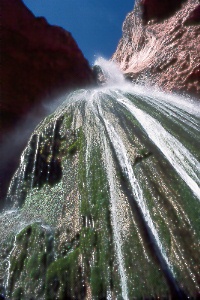
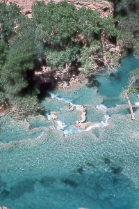 The
mineral-laden water of Havasu Creek forms these beautiful pools enclosed by travertine.
This view is from the top of Havasu Falls.
The
mineral-laden water of Havasu Creek forms these beautiful pools enclosed by travertine.
This view is from the top of Havasu Falls.
Hikers can reach the creek and its waterfalls by hiking in from the trailhead
at Hualapai Hilltop off old Route 66. The Havasupai Indians own this tributary of
the Grand Canyon; they issue permits and provide camping and motel facilities.
On to Photos of Navajo Country in Northeastern
Arizona
Back to beginning of Photo Gallery
Home