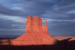
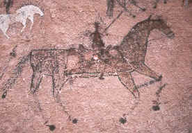
 West
Mitten in Monument Valley
West
Mitten in Monument Valley
West
Mitten in Monument Valley
You too can ride through this valley where Indians, prospectors, and movie stars once passed! The land now belongs to the Navajo Indians, who offer jeep tours, horseback trips, and hikes, or you can drive a scenic loop in your own vehicle.
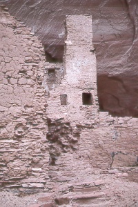
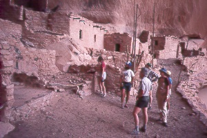
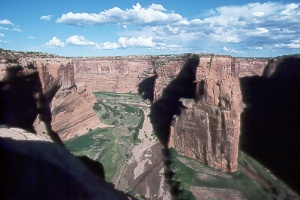 Canyon
del Muerto in Canyon de Chelly National Monument
Canyon
del Muerto in Canyon de Chelly National Monument
Overlooks from two scenic drives provide spectacular views such as this. Trails, horseback rides, and jeep tours can take you inside the canyons for a close look at prehistoric cliff dwellings and traditional Navajo life. With the exception of White House Ruin Trail, visitors entering the canyons must be accompanied by an authorized Navajo guide or monument ranger. This rule is strictly enforced. It protects the ruins and the privacy of families living in the canyons. All land belongs to the Navajo people; the National Park Service administers policies only within monument boundaries.
The main canyons are 26-mile-long Canyon de Chelly (pronounced d'SHAY)
and adjoining 35-mile-long Canyon del Muerto. Sheer sandstone walls rise up to 1,000
feet, giving the canyons a fortress-like appearance. Rim elevations range from 5,500
feet at the visitor center to 7,000 feet at the end of the scenic drives. Allow
at least a full day to see some of the monument's 83,840 acres. April to October
is the best time to visit. Winter brings cold weather and a chance of snow. Afternoon
thunderstorms arrive almost daily in late summer, bringing thousands of waterfalls
that cascade over the rims, stopping when the skies clear.
 Navajo
art in Canyon del Muerto
Navajo
art in Canyon del Muerto
 Antelope
House Ruin in Canyon del Muerto
Antelope
House Ruin in Canyon del Muerto
 Keel
Seel, Navajo National Monument
Keel
Seel, Navajo National Monument
This isolated cliff dwelling is the largest in Arizona and one of the best preserved
in the Southwest. Keet Seel (Navajo for Broken Pottery) features 160 rooms and four
kivas. The ruins look as though they were abandoned just a few years back, not seven
long centuries ago. The site, 8.5 miles away by trail from the visitor center, is
open from the end of May to early September. A permit is required, and there's a
limit of 20 people per day.
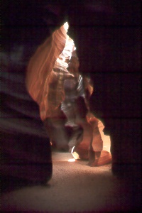
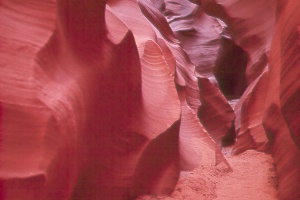
| Antelope Canyon has a wider upper section known as "Corkscrew" and a narrower lower section. Sunshine reflects off the smooth Navajo Sandstone to create extraordinary light and colors. It's also very dim. Photographers wouldn't wish to spoil the effect with a flash, so they bring a tripod to help capture the infinite shapes and patterns. Beams of light enter the canyons at midday, further entrancing visitors. Parts of the canyon are so narrow that you have to squeeze through passages of beautifully convoluted red rock. The shallow wash in between that you see from the highway gives no hint of the marvels up- or downstream. Both can easily be reached from Page by driving south on Coppermine Road or east on AZ 98 to Big Lake Trading Post, then continuing east one mile on AZ 98 toward the power plant. Turn right into the parking area for the upper canyon or stay on AZ 98 just 0.15 mile farther, then turn left half a mile at the sign on paved Navajo Route N22B (Antelope Point Road) for the lower canyon. At either place you'll pay a tribal entry permit plus shuttle or tour fees. | |
|
|
|
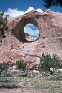 Window
Rock
Window
Rock
The "window" is a great hole averaging 47 feet across in a sandstone
ridge. Loose stones just below the hole mark the site of a prehistoric Indian pueblo.
You're not allowed to climb up to the hole, though a trail around to the left passes
through wonderfully sculptured hills. The park has picnic tables, water, and restrooms;
day-use only. Navajo Nation Veterans Memorial here honors warriors of all eras of
war and peace. It's in the town of Window Rock, capital of the Navajo Nation; turn
east at the sign off Indian Route 12 about a half mile north of AZ 264, then head
a half mile in, passing the Council Chambers on your left just before the park.
On to Photos of Eastern Arizona
Back to beginning of Photo Gallery
Home